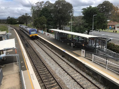
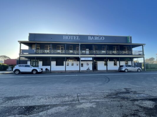
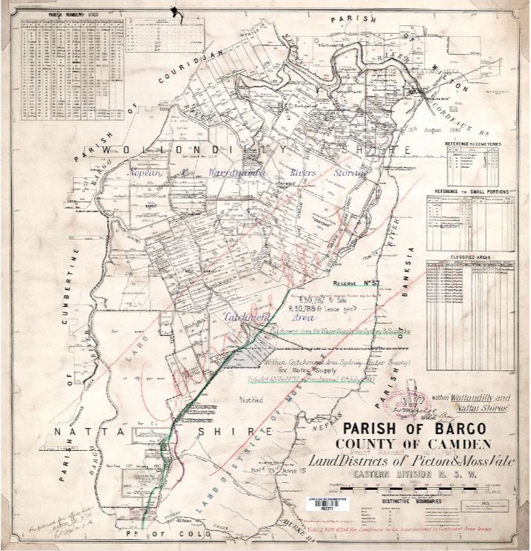
The town of Bargo is on the traditional country of the D’harawal people. Europeans initially travelled through the area in 1790s with the first reference to the area being called ‘Barago’, the indigenous name for the area.

An excerpt from Governor Macquarie’s journal describes the area at the time “On entering Bargo we found the country barren and very bare of feed or cattle, but on advancing a few miles into the country we found both the land and grassing improve a little but far from good. 

Here Mr Oxley and Mr Moore (with my permission) have large herds of horned cattle grazing, but so many of them have died that these gentlemen intend moving them immediately from this country.  After halting a few minutes at Mr Oxley’s stock-yard we proceeded to that part of Bargo where a great number of trees have been blown down by some violent tempest and appears as if they had been felled on purpose to clear the land.  

Hotel Bargo
Bargo River Timber Bridge
Historic West Bargo Subdivision Release Map
Previous
Next

From this place proceeded to view that part of the great branch of the River Nepean where the Bargo branch forms a junction with it and where the banks of the former are very high and rocky.  Governor Macquarie’s Journal of a Tour – entry 6 October 1815 describing the area between Tahmoor and Bargo.  

BARGO RIVER VIADUCT The original timber bridge over the Bargo River north of Bargo was completed in 1898.  For many years it was a bottle-neck on the Hume Highway as it was a single lane bridge. This was later  replaced in 1967. 
The Bargo River Railway Viaduct is located north of Bargo, near the outskirts of Tahmoor. The current brick bridge was built in 1919. The bridge is on the NSW state heritage register,  having been designed by New South Wales Government Railways. Many of the bricks used to build the arched spans were from the State Brickworks in Homebush.
As pictured in the image above, the area below the bridge was often used as a swimming hole and picnic area by locals. The area is now known as the Bargo River Reserve and is still used for swimming and picnics. We would love to see photos from people who have memories of swimming or picnicing there over the years

The Potholes 
From Rockford Bridge near Tahmoor on Rockford Road, where it crosses the Bargo River you will find the  Potholes. These pothole have been enjoyed for generations. They are at times crystal clear, allowing the viewer to peer into the depths of the river, the water bending light, making the water appear shallow. It is believed that these potholes formed when a circular current of water carrying small pebbles and sediment wore away at the rock’s surface. Here Suzy Brandstater reminisces about visiting the potholes as a child!

BARGO RAILWAY STATION  The original railway station at Bargo, which used to be called West Bargo, has a heritage listed toilet block which is now used as a storeroom.  1n 1993 the signal room and station building were damaged by fire and demolished with a promise of a new buidling to replace it. This has not yet eventuated and a demountable unit still takes place of the original building.

The railway bears a significant connecting historical element for all three bicentennial towns. The above image dates back to October 1940 showing an early steam locomotive stopped just outside Bargo station. It was  a 3245 Locomotive on the Federal City Express line to Canberra, stalled on bank near Bargo because it was low in steam. The station is still on the Sydney to Goulburn route, and  now services commuter traffic to Sydney. 

The railway has its own interesting history, with what Bargo local Lynne Greenwood calls ‘The Great Train Robbery’. In December 1941 thieves put an explosive object on the tracks south of Bargo, near Yanderra and a Payroll train was destroyed. Two people in ‘White shorts’ were described leaving the scene of the crime, leaving death, injury and bank notes flying around behind.(https://trove.nla.gov.au/newspaper/article/112768954)

THE HOTEL BARGO The Hotel Bargo was opened in 1926 with John Joseph Cleary as the proprietor. There had been a number of previous Inns during the old coaching days. There was some objection to the granting of the license, especially from the resident engineer of the Avon Dam as it would ‘interfere with the efficiency of the workman employed at Avon’. Despite objections the petition was granted with the hotel opening on July 9, 1926. Tooths Brewery owned the hotel until 1981 when freehold title was purchased by FJ Deegan. It has changed hands a number of times since then and the current licensees have been in Bargo since 2017.


BARGO POST OFFICE Postal services in Bargo have been available since the early days of settlement.
Residents had a mail service six days a week when coaches ran through Bargo with the letters being dropped off at William Anderson’s inn, The Gold-Diggers’ Arms as early as 1839. Coaches were withdrawn in 1867 when the rail line went to Mittagong.  In 1867 the residents petitioned the PMG to establish a PO at Bargo which was approved as from January 1, 1968. The population fluctuated and the PO was closed in 1872 reopening in 1875. The locations of the PO varied and included a slab house opposite the school between 1903-1915. It is believed it moved to the present site in 1922 when the building was a general store as well as a Post Office. During the 1950s the general store part of the building was phased out as other general stores appeared in town. The PO is still on the Great Southern Road Site of 1922.

A little bit of history 

In 1818 the explorer ‘Hume’ travelled through the area. He “accompanied Surveyor James Meehan and Charles Throsby (who in 1804 had penetrated through the Bargo brush to the tablelands country near Moss Vale and Sutton Forest) on a journey to determine if an overland route between Sydney and Jervis Bay could be found.”(Source: The Old Hume Highway – History of a road).  It later became known as the Great South Road (and many years later as The Great Southern Road). 

Settlement of the area began in the 1820s when a cart road to the New Country was being built. Bargo was also one of many Australian towns on the Cobb and Co. coach route  with a history of  bushrangers,  due in part to the dense bushland. The area had such a reputation for the dense bushland, that it was referred to in a version of a folk song ‘Stringybark and Greenhide’ (circa 1865) .
“If you travel on the road, and chance to stick in Bargo,
To avoid a bad capsize, you must unload your cargo;
For to pull a dray about, I do not see the force on,
Take a bit of greenhide, and hook another horse on.”
(Edwards, Ron (1991). Great Australian Folk Songs. Willoughby: Ure Smith. p. 354. ISBN 0-7254-0861-8.)

The Bargo railway was opened in July 1919 and saw significant growth in the town.  The town was originally part of the Hume Highway route, with high volumes of traffic through the town until it was eventually bypassed in 1980.

Our Thanks to Marjo Hallowell for providing historical context and commentary in support of the information about Bargo.

1907 Historic Bargo Parish Map NSWLRS
1974 Historic Bargo Parish Map NSWLRS

BARGO HISTORIC MAPS  The above historical maps are early parish maps of Bargo from 1907 and 1974.

Wollondilly Shire is on Aboriginal land and the country of the D’harawal and Gundungurra peoples. While celebrating the bicentenary of Bargo, Picton and Tahmoor since European settlement we acknowledge their traditional custodianship and culture over countless generations. The deep connection of Aboriginal people to this country continues a rich traditional of culture and custodianship. May we all walk forward together into the future.


200 Bargo Tahmoor Picton is a Wollondilly Shire Council project delivered by STA and possible because for the generous contribution of Picton and District Historical and Family Society Inc., The Wollondilly Heritage Museum,  Historians Trish Hill, Doreen Lyon, Frank Baker, Marjo Hallowell and Marlane Fairfax.

[email protected]
0405 339 838  
Or by appointment at one of our
Mobile Office locations

PO Box 1323 Goulburn 2580
ABN 67 208 214 681


We acknowledge Aboriginal people as the traditional custodians of the lands where we create, live & work. 

© Southern Tablelands Arts. All Rights Reserved